
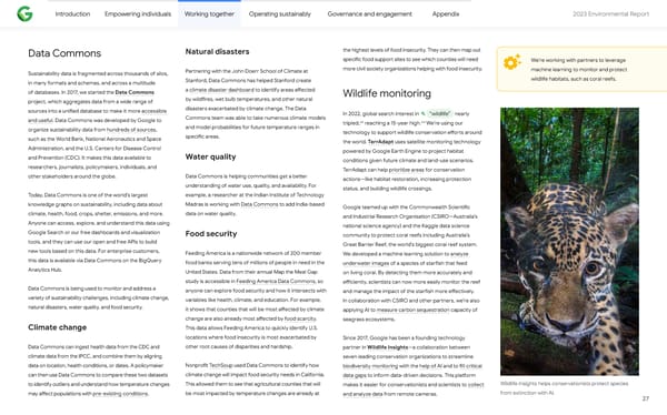
Introduction Empowering individuals Working together Operating sustainably Governance and engagement Appendix 2023 Environmental Repo爀琀 Natural disasters the highest levels of food insecurity. They can then map out Data Commons speci昀椀c food suppo爀琀 sites to see which counties will need We’re working with pa爀琀ners to leverage more civil society organizations helping with food insecurity. machine learning to monitor and protect Pa爀琀nering with the John Doerr School of Climate at Sustainability data is fragmented across thousands of silos, wildlife habitats, such as coral reefs. Stanford, Data Commons has helped Stanford create in many formats and schemas, and across a multitude of databases. In 2017, we sta爀琀ed the Data Commons a climate disaster dashboard to identify areas a昀昀ected Wildlife monitoring by wild昀椀res, wet bulb temperatures, and other natural project, which aggregates data from a wide range of disasters exacerbated by climate change. The Data sources into a uni昀椀ed database to make it more accessible In 2022, global search interest in “wildlife” nearly Commons team was able to take numerous climate models and useful. Data Commons was developed by Google to 63 64 tripled, reaching a 15-year high. We’re using our and model probabilities for future temperature ranges in organize sustainability data from hundreds of sources, technology to suppo爀琀 wildlife conservation e昀昀o爀琀s around speci昀椀c areas. such as the World Bank, National Aeronautics and Space the world. TerrAdapt uses satellite monitoring technology Administration, and the U.S. Centers for Disease Control Water quality powered by Google Ea爀琀h Engine to project habitat and Prevention (CDC). It makes this data available to conditions given future climate and land-use scenarios. researchers, journalists, policymakers, individuals, and TerrAdapt can help prioritize areas for conservation Data Commons is helping communities get a be琀琀er other stakeholders around the globe. actions—like habitat restoration, increasing protection understanding of water use, quality, and availability. For status, and building wildlife crossings. example, a researcher at the Indian Institute of Technology Today, Data Commons is one of the world’s largest Madras is working with Data Commons to add India-based knowledge graphs on sustainability, including data about Google teamed up with the Commonwealth Scienti昀椀c data on water quality. climate, health, food, crops, shelter, emissions, and more. and Industrial Research Organisation (CSIRO—Australia’s Anyone can access, explore, and understand this data using national science agency) and the Kaggle data science Google Search or our free dashboards and visualization Food security community to protect coral reefs including Australia’s tools, and they can use our open and free APIs to build Great Barrier Reef, the world’s biggest coral reef system. new tools based on this data. For enterprise customers, Feeding America is a nationwide network of 200 member We developed a machine learning solution to analyze this data is available via Data Commons on the BigQuery food banks serving tens of millions of people in need in the underwater images of a species of sta爀昀ish that feed Analytics Hub. United States. Data from their annual Map the Meal Gap on living coral. By detecting them more accurately and study is accessible in Feeding America Data Commons, so e昀케ciently, scientists can now more easily monitor the reef Data Commons is being used to monitor and address a anyone can explore food security and how it intersects with and manage the impact of the sta爀昀ish more e昀昀ectively. variety of sustainability challenges, including climate change, variables like health, climate, and education. For example, In collaboration with CSIRO and other pa爀琀ners, we’re also natural disasters, water quality, and food security. it shows that counties that will be most a昀昀ected by climate applying AI to measure carbon sequestration capacity of change are also already most a昀昀ected by food scarcity. seagrass ecosystems. Climate change This data allows Feeding America to quickly identify U.S. locations where food insecurity is most exacerbated by Since 2017, Google has been a founding technology other root causes of disparities and hardship. Data Commons can ingest health data from the CDC and pa爀琀ner in Wildlife Insights—a collaboration between climate data from the IPCC, and combine them by aligning seven leading conservation organizations to streamline Nonpro昀椀t TechSoup used Data Commons to identify how data on location, health conditions, or dates. A policymaker biodiversity monitoring with the help of AI and to 昀椀ll critical climate change will impact food security needs in California. can then use Data Commons to compare these two datasets data gaps to inform data-driven decisions. This pla琀昀orm Wildlife Insights helps conservationists protect species This allowed them to see that agricultural counties that will to identify outliers and understand how temperature changes makes it easier for conservationists and scientists to collect from extinction with AI. be most impacted by temperature changes are already at may a昀昀ect populations with pre-existing conditions. and analyze data from remote cameras. 27
 2023 Environmental Report Page 26 Page 28