
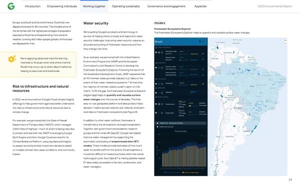
Introduction Empowering individuals Working together Operating sustainably Governance and engagement Appendix 2023 Environmental Repo爀琀 Europe, and South and Central America. Flood Hub now Water security FIGURE 8 displays forecasts for 80 countries. This includes some of Freshwater Ecosystems Explorer the territories with the highest percentages of population We’re pu琀琀ing Google’s products and technology in The Freshwater Ecosystems Explorer helps to quantify and visualize su爀昀ace water changes. exposed to 昀氀ood risk and experiencing more extreme service of helping others to study and respond to water weather, covering 460 million people globally. All forecasts security challenges. Improving water security requires an are displayed for free. accurate accounting of freshwater resources and how they change over time. As an example, we pa爀琀nered with the United Nations We’re applying advanced machine learning Environment Programme (UNEP) and the European methods to forecast when and where riverine Commission’s Joint Research Centre to develop the 昀氀oods may occur, up to seven days in advance, Freshwater Ecosystems Explorer. Following the launch of helping to save lives and livelihoods. the Sustainable Development Goals, UNEP requested that all 193 member states provide indicator 6.6.1 data on the 59 extent of their water-related ecosystems. At that time, the majority of member states couldn’t repo爀琀 on this Risk to infrastructure and natural resources metric. To 昀椀ll this gap, the Freshwater Ecosystems Explorer (sdg661.app) helps to quantify and visualize su爀昀ace water changes over the course of decades. This free, In 2022, we announced our Google Cloud climate insights easy-to-use geospatial pla琀昀orm and data product helps o昀昀erings to help government agencies be琀琀er understand decision-makers access national, sub-national, and basin- the risks to infrastructure and natural resources due to level data on freshwater ecosystems (see Figure 8). climate change. In addition to other water ou琀昀lows, freshwater is For example, we pa爀琀nered with the State of Hawaii transferred to the atmosphere via evapotranspiration. Depa爀琀ment of Transpo爀琀ation (HDOT), which manages Together with government and academic research 2,500 miles of highway—much of which is facing risks due groups and the nonpro昀椀t OpenET, Google has helped to erosion and sea level rise. HDOT is leveraging Google improve water management by suppo爀琀ing the Ea爀琀h Engine and other Google Cloud services for its Climate Resilience Pla琀昀orm, using big data and insights automation and scaling of evapotranspiration (ET) models. These models provide estimates of how much to assess risk and prioritize investment decisions based water is transferred from the land to the atmosphere, a on multiple climate risks, asset conditions, and community crucial but di昀케cult to measure process within the overall impact. hydrological cycle. Now OpenET is making satellite-based ET data widely accessible to farmers, landowners, and water managers. 24
 2023 Environmental Report Page 23 Page 25